
Weather Map & Summary
Pacific Central US Geo Color And IR Satellite
North Lake Tahoe 7 Day Weather Forecast
South Lake Tahoe 7 Day Weather Forecast
Carson City 7 Day Weather Forecast
South Lake Tahoe Snow Depth And Accumulation (Fallen Leaf: Elevation 6240 feet)
North Tahoe Snow Depth And Accumulation (Independence Creek: Elevation 6435 feet)
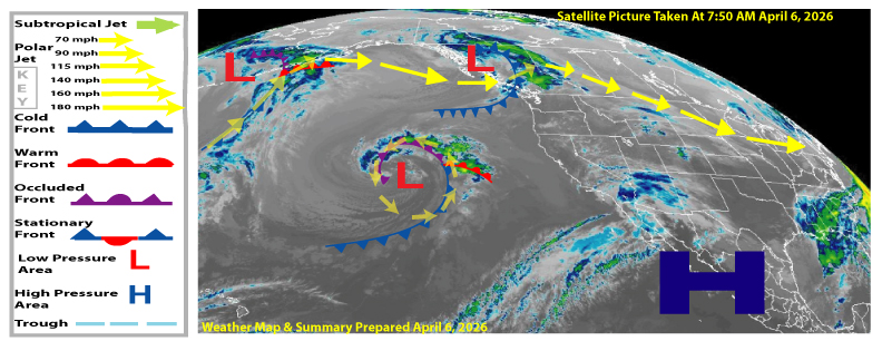
Weather Map And Summary Description
The letter, L on the map represents low pressure and the letter H on the map represents high-pressure. The blue lines with triangles on them represent a cold front and the red lines with half circles on them represent a warm front. A stationary front will be a red and blue line with alternating blue triangles and red half circles. An occluded front will be indicated by a purple line with purple half circles and purple triangles. The polar Jetstream is indicated by yellow arrows and the longer the arrows, the stronger, the Jetstream. Green arrows represent the tropical Jetstream, which is shown much less frequently as the polar jet is much more pronounced, especially in the winter months. A trough of low pressure is indicated by light blue dashed line.
Areas Covered By Weather Map And Summary
The satellite and weather map is prepared for the following downtown areas: Kings Beach, Tahoe City, Truckee, incline Village, South Lake Tahoe, Reno, Carson, City, Minden, Dayton, Fernley, Fallon, Silver, Springs, an Yerington. The date and time that the satellite picture was taken are indicated in green writing on the map. The summary portion of this page which is below, will be discussed in the context of a seven day forecast period.
Tahoe-Reno-Carson Weather Map And Summary
Prepared for the downtown areas of King Beach, Tahoe City, Truckee, Incline Village,
South Lake Tahoe, Reno, Carson City, Minden, Dayton, Fernley, Fallon, Silver Springs and Yerington
Short range (Monday through Wednesday): High -pressure will dominator our weather through Wednesday producing above average temperatures with mostly fair skies. One exception will be Monday where there will be considerable high cloudiness.
Long range (Thursday through Sunday): A low pressure area moving in from the west will produce mostly cloudy skies with a good chance of afternoon and evening showers and thunderstorms Thursday through Sunday.
.
Views: 269